The Eastern
Neighborhoods CFD
With their life science and office campuses and robust warehouse, production, distribution, and repair facilities, the eastern neighborhoods have long served as the city’s largest business district and its most significant economic generator. However, the area suffers from ongoing transportation challenges, including traffic congestion, safety, and aging infrastructure, that pose a risk to the long-term health of existing businesses as well as the future growth of the area. For these neighborhoods to remain competitive in today’s difficult market, targeted investments need to be made throughout the proposed improvement area, seen in the map to the right.
Scroll down to learn more about this proposed effort.
ROADWAY REHABILITATION
As part of the Eastern Neighborhoods CFD, road conditions in the area would see major improvement through a significant investment in roadway rehabilitation.
Benefits include:
Approx. 17 miles of city-owned streets would be rebuilt and/or repaved.
30 intersections would see improvements to facilitate more efficient movement of cars and trucks, as well as safer crossing for pedestrians and bicyclists.
Transit Facilities
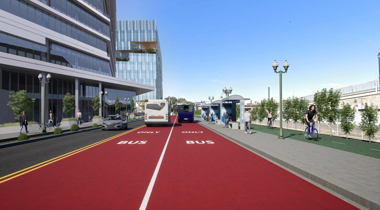
Key transit corridors, such as Oyster Point, East Grand, Gateway, and South Airport, would incorporate bus and shuttle service, enhanced bus stops, transit signal priority, and transit lanes.
Benefits include:
1.6 miles of transit-only lanes alongside existing lanes for cars and trucks
24 bus stop upgrades and access improvements
2 access improvements at regional transit hubs (Caltrain and Ferry)
Pedestrian Improvements
Pedestrian improvements would utilize proven features to create more walkable environments within the area’s key and emerging nodes.
Benefits include:
Approx. 46 pedestrian crossing enhancements
Wider sidewalks, landscaping, parklets, and curb extensions to enhance the safety and experience of walking
Bicycle Facilities
Bicycle improvements in the area help connect regional transit stations and employment centers via separated bikeways and trails, facilitating local and cross-town travel for people of all ages and abilities.
Benefits include:
5.4 miles of new separated bikeways and trails
5 bikeway connections across Highway 101
Land Use in the Eastern Neighborhoods
The amount that property owners will be assessed annually will be determined by the size and use of the development on their parcels within the CFD study area. For the purposes of the Eastern Neighborhoods CFD, the City has consolidated all land uses into three categories:
Warehouse/Industrial/Other
Life Science & Office
Residential
Currently, no residential units have been completed in the Eastern Neighborhoods, but projects are under development.
Each land use category will pay a slightly different rate to reflect their impact on and use of transportation infrastructure within the Eastern Neighborhoods area. Scroll down to learn more about the proposed rates and the projects that they may fund and join us at a community town hall as we discuss more about these rates, projects, timelines, and more.
Proposed Annual Rates
The rates proposed to be assessed as part of this CFD are designed to reflect how businesses within each land use typically utilize the transportation infrastructure of the Eastern Neighborhoods area and the impacts upon that infrastructure that they impart. The costs indicated below are annual, and show how much each land use will be assessed per square foot of developed area for the first year. Continue scrolling to learn about the important transportation projects that may be funded by this investment.
Life Science & Office
$0.65
per square foot of developed area
Residential
$0.25
per square foot of developed area
Warehouse/Industrial/Other
$0.05
for the first ≤ 25,000sf
of developed area
$0.10
for the next 25,001–50,000sf
of developed area
$0.15
for all remaining developed area
>50,000sf
Proposed Projects
The projects proposed as part of the Eastern Neighborhoods CFD have been identified through the City’s planning efforts, including the General Plan, Active South City, and Mobility 20/20, as well as conversations with local stakeholders, as interventions that can have major impacts on the area’s transportation challenges.
The cost of implementing the majority of the projects proposed in this package is estimated to be between $150 and $180 million.
-
Key Features
Structural improvements and repaving of all city streets (approximately 17 miles) in the East of 101 area.Est. Total Cost
$20,000,000 (2024 dollars)
$31,000,000 (2035 dollars) -
Key Features
Adds westbound bus lanes, a two-way protected bikeway, and pedestrian improvements. Bike and pedestrian facilities extend as a shared-use path over US-101. Road is widened east of Veterans Blvd.Est. Total Cost
$29,100,000 (2024 dollars)
$47,650,000 (2035 dollars) -
Key Features
Adds bus lanes, a protected bikeway, and pedestrian improvements. Road is widened east of Forbes Blvd./Harbor Way.Est. Total Cost
$20,650,000 (2024 dollars)
$33,800,000 (2035 dollars) -
Key Features
Addresses needs identified in the City’s Caltrain Access Study, including improvements to bicycle and pedestrian facilities, the freeway offramp, traffic signals, and the creation of a new shuttle-only ramp.Est. Total Cost
$16,850,000 (2024 dollars)
$27,600,000 (2035 dollars) -
Key Features
Closing gaps in trails and the addition of new signals north of East Grand to connect with existing trails along Forbes Blvd. and Eccles Ave. Pedestrian and bicycle improvements continue on Harbor Way between East Grand Ave. and the new Railroad Ave.Est. Total Cost
$13,290,000 (2024 dollars)
$21,720,000 (2035 dollars) -
Key Features
Creates a Class I bike and pedestrian path between the Bay Trail and the Caltrain Station and a dedicated bus lane between Corporate Dr. and Grand Ave.Est. Total Cost
$6,550,000 (2024 dollars)
$10,700,000 (2035 dollars) -
Key Features
Closes gaps in pedestrian connectivity along Gateway Blvd., and improves street signals. Formalizes Corporate Dr. as city street.Est. Total Cost
$5,700,000 (2024 dollars)
$9,300,000 (2035 dollars)
Top Priority
-
Key Features
Establishes multi-use trails along the abandoned rail corridor and Colma Creek, primarily south of the Railroad Ave. corridor.Est. Total Cost
$9,550,000 (2024 dollars)
$15,650,000 (2035 dollars) -
Key Features
Implements a road diet and improves intersections to increase vehicular safety, and adds pedestrian improvements and a separated bikeway.Est. Total Cost
$10,200,000 (2024 dollars)
$16,700,000 (2035 dollars) -
Key Features
Adds a two-way protected bikeway and new pedestrian improvements to close a gap in the Bay Trail.Est. Total Cost
$28,950,000 (2024 dollars)
$47,300,000 (2035 dollars) -
Key Features
Adds a traffic signal for the US-101 offramp and onramp. Creates roadway improvements at the Produce Ave./San Mateo Ave./Airport Blvd. intersection. Creates a new bike and pedestrian trail along Produce Ave., transitioning to separated bikeway on Airport Blvd.Est. Total Cost
$13,800,000 (2024 dollars)
$22,550,000 (2035 dollars) -
Key Features
Adds a trail crossing over US-101 that connects the Bay Trail with the South Linden Ave. grade separation.Est. Total Cost
$14,850,000 (2024 dollars)
$24,280,000 (2035 dollars)
Secondary Priority
-
Key Features
Creates a new street and bike/pedestrian trail along the existing rail corridor between Sylvester Rd. and Littlefield Ave. Redesigns the intersection at East Grand Ave. and Littlefield Ave. Extends the new trail under US-101.Est. Total Cost
$22,000,000 (2024 dollars)
$36,000,000 (2035 dollars)
Tertiary Priority
Roadway Diagrams
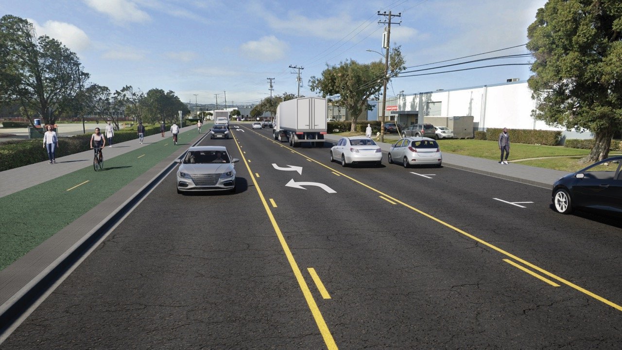
Roadways across the Eastern Neighborhoods have been analyzed and redesigns proposed to provide improvements both for users that currently utilize the streets and those that are expected to utilize them in the future. These diagrams are only conceptual, but click each to enlarge it and learn more.
Project Visualizations


East Grand Avenue (looking east)


Oyster Point Boulevard (looking west)


Utah Avenue (looking west)


Poletti Way (looking south)


Caltrain Station Area (looking east)


